EpicArtifacts

Announcement

Collapse
No announcement yet.

Canadian unit designation help

Collapse
X
 
  • Filter
  • Time
  • Show
Clear All
new posts

    #16
    Canadian unit designation help

    https://clarencesimonsen.files.wordp...s-cuxhaven.pdf

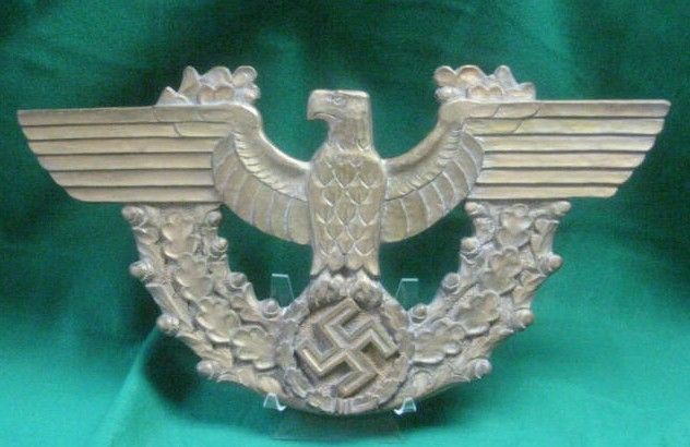
    There was no doubt some movement of units in that time frame. Maybe an element of a Canadian unit moved through there briefly. Canadians were certainly in the general area, it seems.


    Or maybe the date is inaccurate.


    http://pipesforfreedom.com/webtxt/05..._OF_CANADA.htm

    Sent from my iPhone using Tapatalk Pro

    Comment


      #17
      Canadian unit designation help

      https://www.ibiblio.org/hyperwar/UN/...OpSumm-16.html

      Looks like Canadian territory from this narrative and map.

      Sent from my iPhone using Tapatalk Pro

      Comment


        #18
        Ops you better retake you map reading course

        That is the map from the Official History of the Canadian Army

        Same one I used.

        If you look closely you will see it is the Second British Army that is sown surrounding Bremem. They where the occupiers of that area.

        The First Canadian Army 'Lanes' where the North Sea, 10 miles from the left bacn of the Kinten canal to the left bank of the Weser river.

        That is over 30km from Cuxhaven so they where no where near there at all. There was talk of operation in this area as one of you history mention

        "At one time it seemed possible that the Army's responsibilities might be extended to include the capture of Bremen and the Cuxhaven peninsula. But the rapid advance of the Second Army and the other commitments of the 1st and 2nd Canadian Corps made it necessary for General Dempsey to assume these tasks. "

        But as the above tell us it was the Second Army that operated in that area in the early May period.

        Like I said before the 3rd Div C.A.O.F. did occupation duties in the general area after May 45 till August 47 I guess it could be called the 'Cuxhaven Peninsula'

        I could of been collected by Canadians but it is lost now to history. Just not enough to go on from that trace it back to a unit.
        Last edited by byterock; 01-26-2017, 07:50 AM.

        Comment


          #19
          Thanks for your comments and guidance guys.

          Comment


            #20
            Canadian unit designation help

            I've read plenty of maps in my career. 30 km is no distance at all for a mobile recon unit that might have made a foray there after hostilities ceased. The Canadians were clearly in the vicinity.


            Sent from my iPhone using Tapatalk Pro
            Last edited by NARVIK1940; 01-26-2017, 10:47 AM.

            Comment


              #21
              Originally posted by NARVIK1940 View Post
              I've read plenty of maps in my career. 30 km is no distance at all for a mobile recon unit that might have made a foray there after hostilities ceased. The Canadians were clearly in the vicinity.
              True but that is 30+ k as the crow flies if we are talking about getting to the city of 'Cuxhaven' on May 9th by a Canadian Unit.

              Then it is over 120k on period road assuming the unit could

              1) drop all duties involved in receiving the local German surrender
              2) make an major unauthorized estuary crossing,
              3) cross over its units, divisional and army boundaries,
              4) move though hostile enemy territory and though many elements of the British second Army unhindered
              5) have none of this appear in the various war diaries entries for the 9th of the 2nd Division


              Like I said there where no Canadian Units in the area on the 9th of May.
              It could of happened later in the month

              Comment


                #22
                Originally posted by JoeW View Post
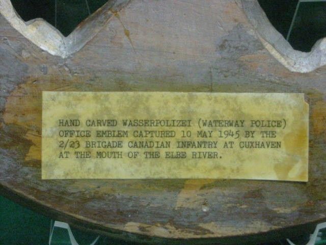
                Sorry I didn't provide this to begin with. From the WSP offices on the docks in Cuxhaven. The office address from period police records is still a functioning pier.


                I would tend to believe this description frankly. Whoever wrote it probably was there then. Looking at old maps and saying they couldn't be there, when there easily could have been undocumented movements of personnel once hostilities ended, casts doubt on the inscription, which looks quite old. I would rather think it is giving us additional data to consider. Maybe there were some Canadians in the British sector? And maybe, as you say, these were ambulance personnel?


                Sent from my iPhone using Tapatalk Pro
                Comment

                Users Viewing this Thread

                Collapse

                There is currently 1 user online. 0 members and 1 guests.

                Most users ever online was 10,032 at 08:13 PM on 09-28-2024.

                Working...
                X